

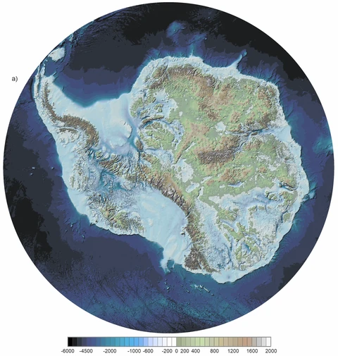
Satellite images of Antarctica reveal an enormous white continent. But the visible ice surface is not the same as the landscape beneath it. Mountains, valleys and basins are hidden under a vast ice sheet, making them inaccessible to ordinary photography.
This is not a completely unknown or never-studied world. Scientists have measured Antarctica's underlying landscape for decades using geophysical techniques. What is changing is the level of detail with which those observations can now be combined.
01MAPPING WHAT THE CAMERA CANNOT SEE
In March 2025, an international team led from the British Antarctic Survey presented Bedmap3, an improved map and dataset describing the land beneath Antarctica's ice sheet. Its purpose is not to show a photograph of an ice-free Antarctica. It is a scientific reconstruction based on many kinds of measurements and modeling.
The project incorporates observations collected since the second half of the twentieth century. According to BAS, it adds 84 aerogeophysical surveys from fifteen data providers, contributing about 52 million data points and 1.9 million line kilometres of measurements. These are totals from assembled datasets, not from a single expedition.
02HOW CAN SCIENTISTS MEASURE THROUGH THE ICE?
Researchers combine information from airborne instruments, satellite observations and field surveys, among other approaches. Measurements of ice thickness and other physical properties help reconstruct the shape of the underlying bed. Survey points from different periods and regions are assembled into consistent mapped surfaces.
A Bedmap3 image should therefore be read as a data-based reconstruction, not as a literal satellite photo with the ice removed. Some areas are supported by denser observations than others. The difference between directly observed measurements and interpolated terrain matters.
03WHY THE HIDDEN LANDSCAPE MATTERS
The shape of the bedrock influences how an ice sheet flows and how it might respond as conditions change. Identifying mountains, channels, basins and low-lying terrain improves scientists' ability to model past and future ice behavior.
Bedmap3 also maps drainage systems and provides context for subglacial lakes. Some pathways are modeled rather than directly observed, and BAS cautions that not every modeled water accumulation is necessarily a real lake.
04IS THE CONTINENT NOW FULLY MAPPED?
No. Bedmap3 provides a major improvement, not perfect knowledge of every valley. Coverage and uncertainty still vary across the continent. A more detailed map does not mean that every feature has been measured equally well.
There are two connected Antarctic landscapes: the ice we can see, and the terrain on which it rests. Understanding both is part of understanding how the continent works.
RADAR ANTÁRTIDA explores the southern continent through primary scientific sources, from Tierra del Fuego to the world. For the underlying data and methods, consult the official Bedmap3 publication and British Antarctic Survey project pages.
VERIFY AND EXPLORE FURTHER
Keep the evidence close.
Sources consulted for this investigation. Check the date and scope of each document.